
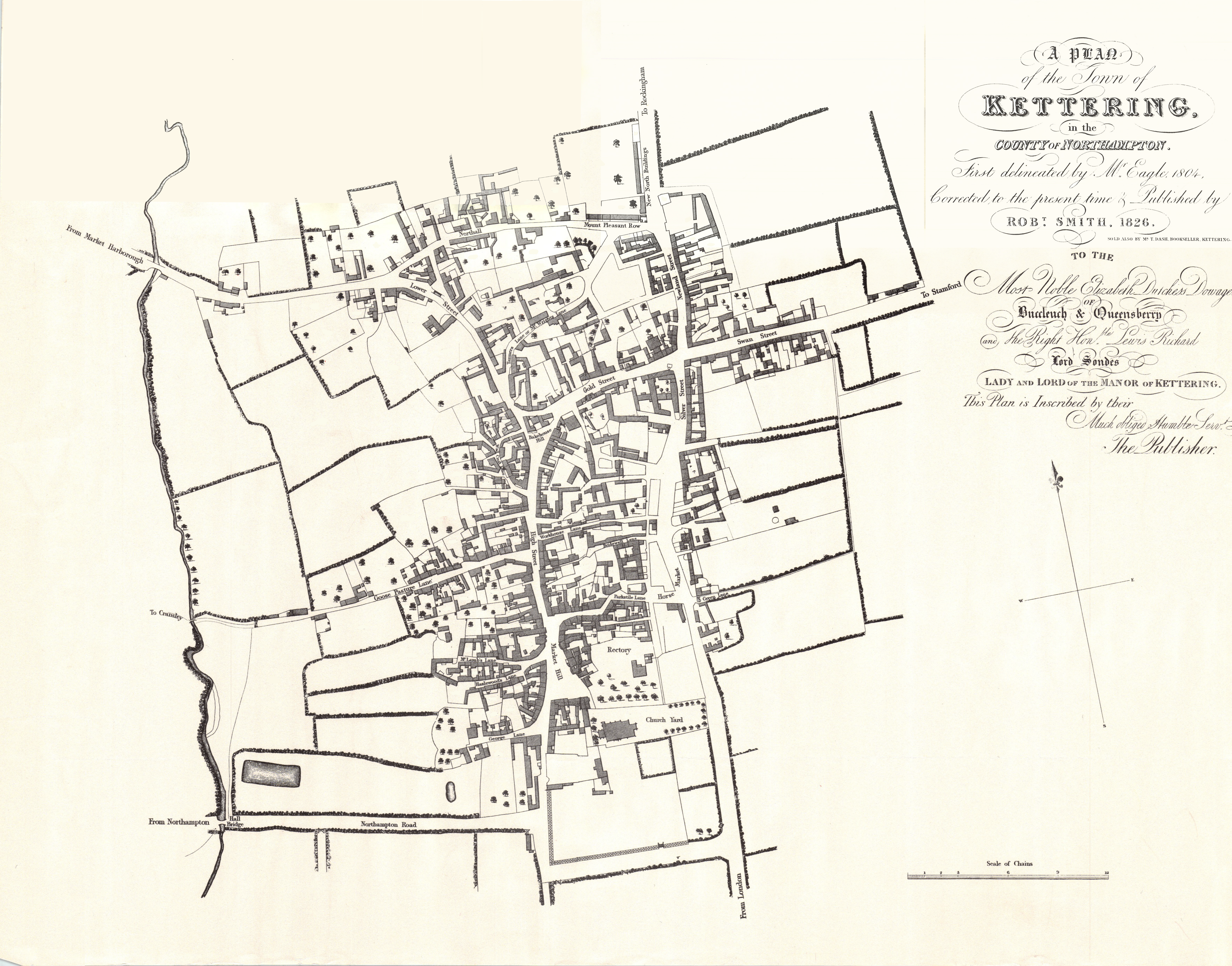
Click to enlarge
You can buy a copy of this map from Kettering Civic Society!
https://ketteringcivicsociety.net/shop.htm
Click on the links below to skip to that section.
| To/From Labels |
| Cransley ● London ● Market Harborough ● Northampton ● Rockingham ● Stamford |
Map Labels
Bakehouse Hill
The cluster of buildings, demolished in 1969, sat where the seating area and clock tower now are.
It was so-called for the bake house which had been present for centuries; a bakery had been there right up to its destruction.
Bell Founder’s Lane
This was where Thomas Eayre had his foundry.
Bridewell Lane
Named for the Bridewell, learn more here.
George Lane
Named for the George Inn.
Formerly called Cock Lane, after a pub called The Cock.
Gold Street
Used to be called Paul’s Street, after Hugh Paul and his son Matthew, who were eminent surgeons.
Goose Pasture Lane
Named for what had been a small patch of common land at the end, used for feeding geese before taking them to the market.
It had alternatively been called Mill Lane for at least a century by the time of this map; this was either for a hemp mill on the grounds, or possibly for a mill from longer ago.
Now called Meadow Road.
Green Lane
There doesn’t seem to be any particular story behind this street’s name. It’s likely that it either was originally a rural track or ran alongside open fields or greenery (as shown in the map) before the town expanded.
Hall Bridge
A bridge crossing the Slade Brook, near the Hall Meadow.
Hazlewood’s Lane
Named for landowner Mr Hazewood who lived at the end of the lane.
High Street
Streets with this name are usually so-called because of their position and location within the town.
Horse Market
Named for the markets of livestock which were held there.
Formerly called Hog Leys, as it was a feeding ground for pigs.
Lower Street and Staunch Lane
Like in most towns, Lower Street was so named because of its relative location in the town.
Its old name was Staunch Lane, from pellucid or vitrified stones, which seemed good for staunching blood.
Market Hill
The charter for Kettering Market was granted by King Henry III in 1227.
Mount Pleasant Row
Fifteen cottages built by, among others, Robert Smith and Jason Bayes; the latter would give his name to a nearby street.
Mr Lamb’s Lane
Attorney Henry Lamb owned several properties on and near this lane.
It had previously been called Dyker’s Lane, and then Nag’s Head Lane, after a pub which had since closed.
New North Buildings
A row of cottages built by Joseph Eady, Thomas Hawthorn, and Robert Smith.
Northall Street
As of 1577 it was called Northhold; a corruption of “North Wold”, from the Anglo-Saxon word weald, meaning “wood land”.
Northampton Road
The road which led to Northampton.
Newland Street
When named, its buildings were newer than others in the town.
Parkstile Lane
Even as of 1821 this was an ancient name, whose meaning was lost to time.
Now called Market Street.
Pudding Bag Lane
Named because, like a bag, it had one opening and a dead end. Learn more here.
Now Called Walker Lane.
Silver Street
“Silver Street” is a name which appears in towns and cities across the country. Sometimes this is due to silversmiths, but there’s no evidence of Kettering having any,
The more likely common reason for this street’s name is a corruption of the word “sylva”, meaning it led to a wooded area.
Before Mount Pleasant Row and the buildings that named Newland Street were built, Silver Street likely led directly onto the end of Northall. Therefore, it’s likely that the “North Wold” was the “Sylva” the street’s name referred to.
Swan Street
Previously known as Dulmore Street and now called Montagu Street (after the family name of the Duke of Buccleuch). It took the name from The Swan Inn, which moved here from the corner of High Street and Turnstile Lane after the 1766 fire.
The line of houses at the end, above the “To Stamford” label, were called Littleworth.
Tanners Lane, or Mr Wrights Lane
Farmers George and Joseph Wright owned a number of properties on and around this street.
The name Tanners Lane came from a yard belonging to a tanner (Wade) having been there.
Wad Croft Lane
Wad = an old Northamptonshire dialect for “woad”, a plant grown to make coloured dye;
Croft = an area of land.
Learn more here!
Workhouse Lane
Named after its workhouse.
Now called Dryland Street, for John Dryland, who formed Kettering Waterworks Company.
To/From Lables
As Kettering grew, the areas to which these roads led started to change…
Cransley
The land between Cransley and the end of Meadow Road has since become built up.
London
This road now leads into The Headlands.
Market Harborough
This road now passes the General Hospital, on its way to Market Harborough.
Northampton
This leads to the A43, meaning it remains a relatively direct route to Northampton.
Rockingham
Now leads into Rockingham Road, and onto Corby.
Rockingham itself is now seen as part of Corby. But at the time of this map, Corby was only what we now called the Old Village. Rockingham was more prominent than Corby, not least because of its castle.
Stamford
This now leads to the estates of Stamford Road, Avondale, and The Grange.
